The toughest part of driving on the left side of the road...
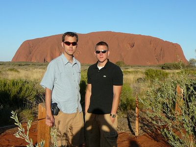
is the turn signal. It's on the right-hand side of the steering column, where you'd expect the wiper to be. So every time we got to an intersection, our windshield got a good washing. Fortunately, there aren't very many intersections in the Outback, and, despite my ineptiude shifting gears with my left hand, we survived our road trip through the Red Centre. Ayers Rock is an amazing sight, but it's quite literally in the middle of nowhere. Just outside the "resort", heading west toward the rock, we passed a sign warning that there's no gas for the next 845 kilometers. That's the distance from Cincinnati to Macon, Georgia.
Ayers Rock (Uluru)

Sunset... John reading a book as we walk around the base of the Rock.


To get from Ayers Rock to Alice Springs, we took Lasseter Highway to Stuart Highway (roads in the Outback don't have numbers - there aren't enough of them) for 400 km. Stuart Highway is a respectable if lightly traveled two-lane road. Lasseter Highway is what I'd expect a main highway to look like in a third-world country - paved, but narrow with only a faded center line for marking. The shoulders were broad and dusty and morphed into the paved roadway with no clear boundary. The bus drove on pavement but left tracks in the sand that covered to road. The sunset along the way was beautiful, though.
Oh, and John lost his jeans.
Ayers Rock (Uluru)

Sunset...
 John reading a book as we walk around the base of the Rock.
The Olgas (Kata Tjuta)
Seven domes rising out of the desert, the walk through the Valley of the WInds (appropriately named) here was better than the base walk at Ayers Rock.


To get from Ayers Rock to Alice Springs, we took Lasseter Highway to Stuart Highway (roads in the Outback don't have numbers - there aren't enough of them) for 400 km. Stuart Highway is a respectable if lightly traveled two-lane road. Lasseter Highway is what I'd expect a main highway to look like in a third-world country - paved, but narrow with only a faded center line for marking. The shoulders were broad and dusty and morphed into the paved roadway with no clear boundary. The bus drove on pavement but left tracks in the sand that covered to road. The sunset along the way was beautiful, though.
Oh, and John lost his jeans.

0 Comments:
Post a Comment
<< Home